Ireland’s Stunning Loop Trails
If you are like many other Irish people and are choosing to stay at home for your summer holidays this summer, why not put on your hiking boots and discover some of Ireland’s scenic and less travelled hiking trails. Enjoy the summer sunshine with a walk along some of Ireland’s stunning loop trails.
Fraughan Loop (County Kilkenny)
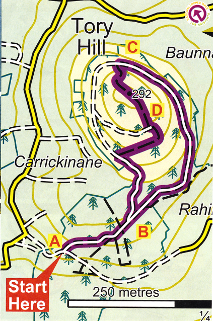
Trailhead: Car Park at Tory Hill, Mullinavat Co Kilkenny
Nearby Services: Mullinavat (3km)
Trail length: 4km and should take 1hr-1hr 30 mins
Difficulty: Moderate
High/Ascent: 292 m/ 150m
Terrain: Trails consists of forestry roads and woodland tracks
Suitable for: Anyone with an average level of fitness
Required Gear: Water, hiking boots and waterproof gear
Walking the trail
A-B
When taking this trail hikers should begin from the car park at Tory Hill and proceed through the Carrickinane Woods entrance. Here you should follow the arrows along the track for approximately 500m until you come to a track uphill on your left hand side. Once here your trek of the loop can begin and is where you will end up once you have completed the trail.
B-C
Continue along the trail, along the gentle ascent along the forest roadway for approximately 1.5 km until you reach a left bend on the trail located near the top of Tory Hill. The green loop is the easier route and continues straight ahead from this point. Hikers should turn left and follow the purple arrows along the grassy path to navigate towards the top.
C-D
Stay along this grassy track going downhill and take a left turn once it joins up with a forestry track. Keep going for another 200m until you join the forestry road that you left on your outward journey then take a right and the trailhead is 500m ahead.
Directions to Trailhead
Start from Mullinavat village on the N9 between Kilkenny and Waterford. Then follow the N9 towards Waterford for a short distance and then take a left onto a minor road. Follow this for approximately 5km to the trailhead.
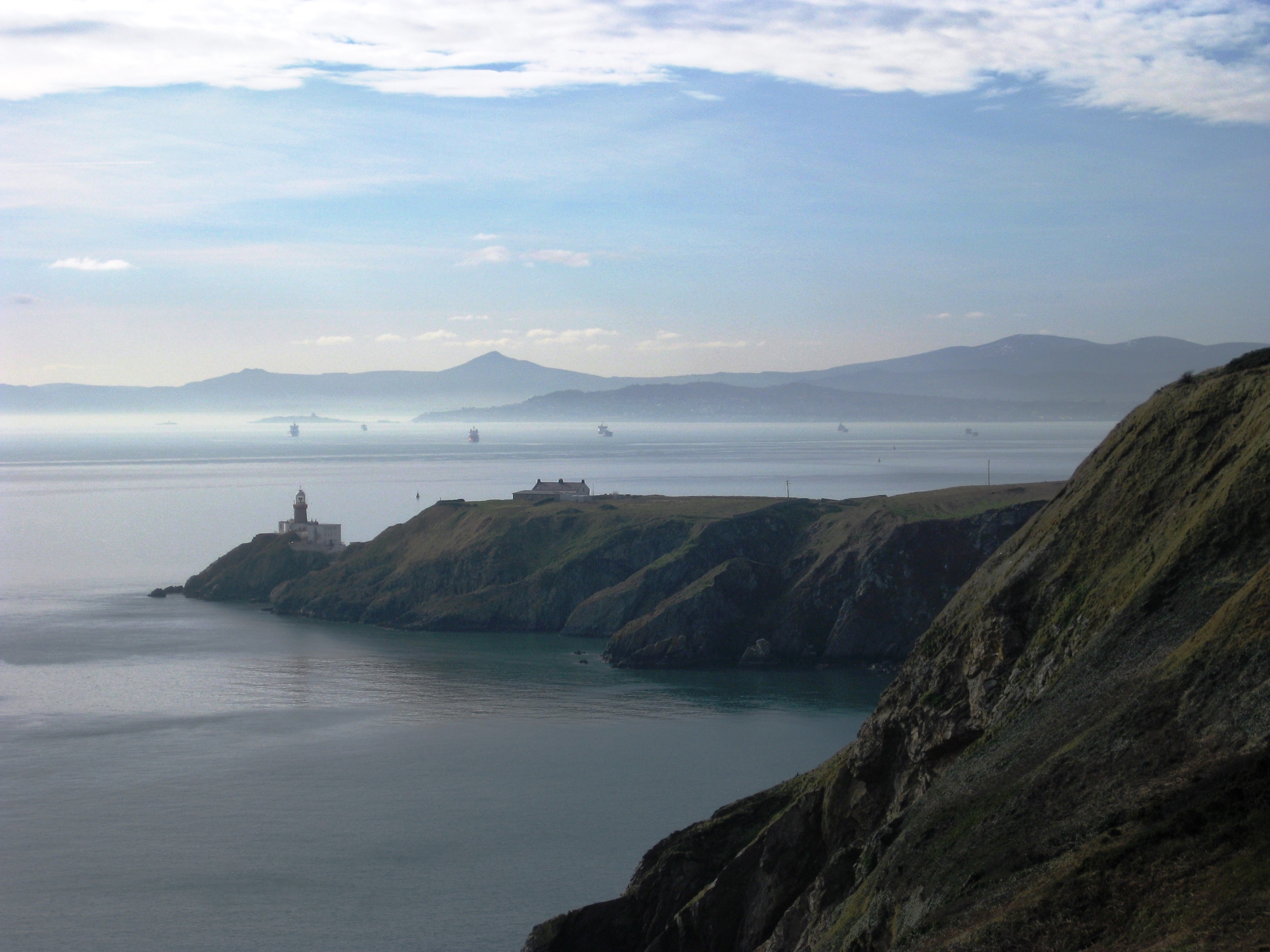
Howth Cliff Path Loop (County Dublin )

Trailhead: Howth Village, County Dublin
Nearby Services: Howth Village
Trail length: 6km and should take 1hr 30 mins-2 hrs
Difficulty: Easy
High/Ascent: 130m
Terrain: Trails consists of cliff top paths and laneways
Suitable for: Anyone with an average level of fitness
Required Gear: Water, comfortable shoes and raingear
Walking the trail
A-B
You should start from Howth DART station and follow the green arrow towards the promenade along the harbour. You will also be following the red, blue and purple arrows which bring you to longer trail loops. When you reach the end of the promenade take a right onto Balscadden Road and go straight until you reach Kilrock car park. Here you will join the main cliff path.
B-C
Once you are on the cliff path, follow it for around 3km and take a right turn and head towards the Summit car park.
C-D
Once you reach the Summit car park, your trail loop will swing right and begin the return journey along a sandy pathway that runs parallel to and above the cliff path. When you reach the end of the sandy pathway, the loop will join Thormanby Road where you take a left. Then take a right onto the Dungriffin Road.
D-A
Walk along the Dungriffin Road for 200m and then turn right and rejoin the blue and red loops on the tramline walkway to bring you back down into Howth village and back to the DART station.
Directions to Trailhead
Howth village is located 15km from Dublin city centre. The trailhead is located at the start of the promenade beside the DART station in the village. An easy way to get there from the city centre is by catching the number 31 or 31B bus from Dublin city centre.
Clogrennan Loop (County Carlow)

Trailhead: Clogrennan Woods, Co Carlow
Nearby Services: Leighlinbridge (6km), Carlow (8km)
Trail length: 4km and should take 1hr -1hr 30 mins
Difficulty: Easy
High/Ascent: 180m/50m
Terrain: Trails consists of forestry roadways and woodland tracks
Suitable for: All levels of fitness
Required Gear: Water, comfortable shoes, raingear and your phone
Walking the Trail
A-B
You should start this tail from the car park, following the purple arrow along the roadway for 500m until you reach a Y-junction in the road. At this point the loop trail begins. Here you should go straight ahead and this is also the point that you will be returning from the trail on your left.
B-C
Continue following the roadway for approximately 200m. After this you will walk over a bridge with a stream flowing underneath. Walk for another 300m where you will see a woodland track on your left. This track will zig-zag uphill where the loop joins a sandy forestry track and turns left.
C-A
The next 500m see’s the terrain change from a sandy track into a forestry roadway. Here you can see stunning views of Carlow Town and the River Barrow on your left. Cross a stream at a concrete ‘ford’ at a sharp left bend and then continue on for another 300m to return to the junction from where you started. Here you should take a right and travel 500m back towards the trailhead.
Directions to Trailhead
Leighlinbridge is a small village on the N9, the main road from Dublin to Waterford. When you reach the Arboretum Garden Centre in the village, turn right onto a minor road signposted for Milford and Ballinabrannagh. After 4.7 km, take a left at the road to Ballinabrannagh and Bilboa. After 1km you will drive into Ballinabrannagh and turn right at the primary school and follow the sign for Clogrennan Lime. The trailhead will be located on your right after about 1km.
Binnianea Loop (County Laois)

Trailhead: Cullahill, Co Laois
Nearby Services: Cullahill (2km), Durrow (10km)
Trail length: 12km and should take 3hrs
Difficulty: Moderate
High/Ascent: 250m/100m
Terrain: Trails consists of forestry tracks, laneways, minor roadways and cross country
Suitable for: All levels of fitness
Required Gear: Water, Hiking boots, raingear and your phone and a snack
Walking the trail
A-B
If you are starting from the mapboard in the car park, follow the purple arrow downhill for 200m to reach a pathway on your right. This path will ascend uphill for 500m to exit the woodland. Pass Cummer Well and after around 200m keep your eyes peeled for the right hand turn into a field. There will be a ring fort on your left here that is worth visiting also. Proceedto follow the purple arrows along the boundaries of fields before joining a roadway. When you get to here turn left.
B-C
Continue along this road for around 1km until you reach the junction with Shirley’s Lane on your right. Take a right turn and follow the laneway for 1km.Keep an eye out for the stile on your left that will take you into a forested area on your right.
C-D
Walk along the boundary fence on the left for 400m before crossing a stream that acts as the Laois and Kilkenny border and entering a forest. Walk for another 100m and you will join a forestry roadway where you should take a left and follow the road for 700m before turning left onto a path. This will take you across the same stream as before and across a field onto Boyles Lane where you take a left.
D-A
Continue walking along Boyles Lane for 1km. You will come to a right bend where the loop crosses a stile. When you get here, ascend along the edge of a field to reach a stone stile. Take a left turn onto the old Heathy Lane and after 500m join a forestry roadway where you turn right. After 300m keep an eye out for the left turn into forestry and follow the path as it takes you downhill and merges onto Two Trees Lane. Once you reach the end of the lane you will exit onto a road where you should turn left. From here it is a 1km walk back to the trailhead.
Directions to Trailhead
The M7 connects Dublin to Limerick. At the halfway point of the motorway the M7 bypasses Portlaoise. Leave the M7 at M7 at Junction 17 and join the N7 in the direction of Abbeyleix. You will drive through Abbeyleix and Durrow before you reach Cullahil. About 2km from the village is the trailhead. Take a left at a picnic area in the village centre and then take a right at the old Tower House. Follow this road for 2km to reach the trailhead which will be located on your left.
Common’s Loop (County Louth)

Trailhead: Tourist Office Carpark, Carlingford, Co Louth
Nearby Services: Carlingford
Trail length: 4km and should take 1hr- 1hr 30 mins
Difficulty: Moderate
High/Ascent: 250m/200m
Terrain: Trails consists of minor roads, laneways and hillside tracks
Suitable for: All levels of fitness
Required Gear: Water, Hiking boots, raingear and your phone
Walking the Trail
A-B
From the tourist office car park, take a left and follow the green arrows along the road until you reach a T-junction where you turn left. Entering the village square turn right and ascend to the main junction where you should go straight on to the right of Savages Victuallers. Continue to follow the green arrows and the loop will take you to the top of River Road. Proceed straight ahead and join a stony laneway.
B-C
Follow the laneway as it zig-zags uphill for approximately 500m to join a wide green roadway. Follow the grassy roadway downhill for 300m to reach a wooden gate. Once you have passed through the gate follow the arrows to the left. The loop will then descend downhill and after 500m it will join a road. Here you will rejoin the Barnavave Loop and turn left and downhill.
C-A
Continue to follow the arrows the arrows as the loop takes you down to the Parish Church on the outskirts of the village, turning left back into the village square. From here it is only 100m back to the trailhead.
Directions to Trailhead
Leave the M1 at junction 18 and join the R173 in the direction of Ballymascanlan and Carlingford. After 15km watch as the R173 turns (signposted Carlingford). A further 3km will take you to the village and the tourist office is in the ain car park on your left.

